Geodynamics of the Yellowstone Hotspot
A Collaborative University of Utah and University of Oregon
NSF-Funded Continental Dynamics Project
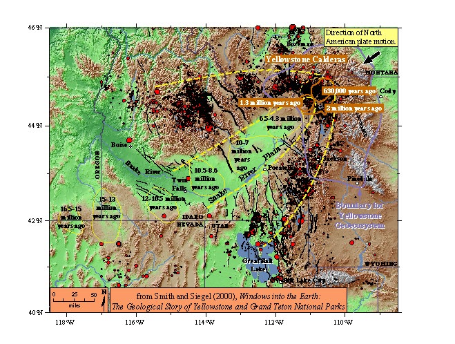 |
Topographic map of the Yellowstone-Snake River plain
showing Quaternary faults, historic earthquakes, and the locations of past caldera eruptions. Over the last 16 million years,
there was a series of giant, caldera-forming eruptions, with the most recent at Yellowstone National Park 630,000 years ago.
(from Windows into the Earth, by Smith and Siegel, © 2000) |
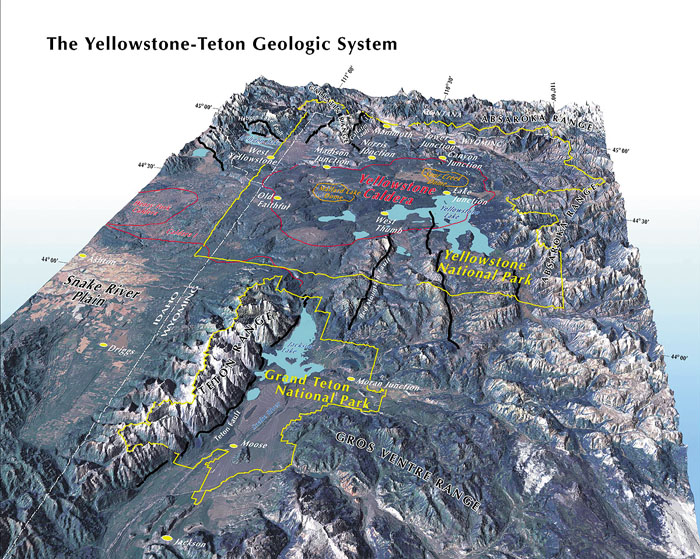 |
Three-dimensional view of the Yellowstone Plateau,
with its active faults and caldera. The plateau is the surface manifestation of lithospheric uplift and active volcanism of the
Yellowstone hotspot.
The Yellowstone plateau, created by a series of volcanic eruptions from the hotspot,
rises above the Snake River plain to the southwest (left). The Yellowstone caldera (outlined in red), in the central plateau,
was created by a giant volcanic eruption 630,000 years ago. The caldera was a 50 x 40 mile depression that was filled in by
younger, smaller eruptions over time. The eruptions that created the plateau rearranged the topography of the land: the plateau
was mountainous region prior to the onset of volcanism, and the mountain ranges to the north and south of the present plateau
were once continuous.
(view looking north from Windows into the Earth, by Smith and Siegel, © 2000) |
Summary of the Yellowstone Hotspot Project
The Yellowstone hotspot has interacted profoundly with the continental lithosphere during its 16 Ma history.
It has produced an 800 km-long track of explosive silicic volcanism along the Snake River Plain that spans five states. Hotspot
activity has produced large earthquakes, affected active faulting, significantly modified the crust and upper mantle (through
melting and igneous intrusions, etc.), and reformed the topography along its track. The hotspot remains active today, and the
accessibility of Yellowstone affords an opportunity to study fundamental, active tectonic and volcanic processes of continental
evolution.
Research Objectives
The Yellowstone geodynamics project is a multi-year, multidisciplinary study of the Yellowstone hotspot. The
goal of the project is to understand how hotspot processes affect tectonism, volcanism, topography, and ultimately how the
hotspot affects plate deformation. The seismic component of the study will provide resolved images of the lithosphere-asthenosphere
structure. These data will be integrated with plate motion information from GPS measurements and Quaternary fault and volcanic
information to produce dynamic models of asthosphere-lithosphere interaction and the intraplate deformation of the Yellowstone-Snake
River Plain (YSRP) within the framework of North American plate motion dynamics, as well as models of magma ascension and storage in
Yellowstone's magma system. This latter element involves detailed studies of the Yellowstone volcanic system, active faulting, and
hydrothermal freatures, and how they are enhanced by regional Basin-Range extension as well as hotspot thermal and magmatic sources.
Dynamic modeling, constrained by seismic and GPS data, will be supplemented by topographic data, volcanic history
of the YSRP, Quaternary faulting, earthquake data, and stress field orientation. Models will address such processes as plume
flattening and small scale convection within the asthenosphere, lithospheric modification through tectonic and magmatic fluxes,
asthenosphere-lithosphere stress, and thermal coupling. The models will also examine how magmatic and heat transport through
Yellowstone's crust interact with faulting, create topography, and drive the hydrothermal system.
Based on our previous research, which included major field
experiments in teleseismic imaging, GPS, earthquake monitoring, heat flow
measurements, seismic profiling of Yellowstone Lake, and Quaternary fault
history, our new seismic and GPS imaging integrated with new volcano models
and fault slip studies will provide information for a unique dynamic model
of the Yellowstone hotspot. This study will allow us to ascertain the driving
mechanisms and rates of geologic processes in Yellowstone and will demonstrate
influence of the Yellowstone hotspot on tectonism of a large region of
the western US.
To carry out this project, we will form a research team of geophysicists and geologists who are recognized
experts on the YSRP hotspot problem. Primary collaborators are:
- Robert B. Smith, University of Utah
- Eugene Humphreys, University of Oregon
- Charles M. Meertens, University of Utah
- Ken Dueker, University of Colorado
- Paul Tackly, UCLA
Additional collaborators include:
- Neil Ribe, Yale University
- Anthony Lowry, Indiana University
- Richard Smith, Idaho National Engineering and Environmental Laboratory
- Suzette Payne, Idaho National Engineering and Environmental Laboratory
- Frank Vernon, University of California at San Diego
- Jennifer Eakins, University of California at San Diego
Field Work
Proposed seismic imaging will obtain information on the structural geometry and composition of a mantle volume to
depths of ~1000 km below Yellowstone. The volume will extend to a depth that includes the presumed mantle plume, the flattened plume
beneath the lithosphere, and the magmatically penetrated lithosphere. It will also provide images of the magmatically modified crust,
Yellowstone's active magma chambers, its active faults, and the plumbing of its world-famous geysers and hotsprings. These are the
processes that have ultimately created the splendid scenery of this world-reknowned and first US national park.
 Seismic imaging home page
GPS measurements and kinematic modeling will resolve the deformation field and velocity vectors around the greater
area of the Yellowstone hotspot and tie them into a western US framework. The models will be constrained by Quaternary geologic
information and petrologic models of silicic, caldera-forming volcanism. GPS data will be obtained from thirteen permanent GPS
stations and a field campaign with ~160 stations. Fault geometries, lengths, ages, and slip rates will be determined from mapped
information and new cosmogenic dating methods.
Yellowstone and Utah GPS Networks
Field work will be done on Quaternary faults and volcanic and hydrothermal features. The data will include detailed heat
flow measurements from Yellowstone Lake obtained by Southern Methodist University in cooperation with the University of Utah. They will be supplementd by three-dimensional,
relocated earthquake hypocentral data, focal depth distribution (for determining depths to the brittle-ductile transition), and the
localized stress field that controls Yellowstone tectonism and volcanism.
© 2000 Robert B. Smith