Continuously streamed digital data (sampled at 40 sps) from the three-component
broadband seismometers are transmitted to two collection towers via spread-spectrum
radios and relayed to a collection site in Billings, MT using a 2.2 GHz
microwave radio. The data are linked to the Internet and are fed into our
primary object ring buffer (ORB) at the University of Utah supplied by
the Antelope software system. Data from four additional networks in the
intermountain west spanning an area ~1,200 km north-south and ~500 km east-west
are being collected along with the Montana broadband data including all
or part of the following networks: the University of Utah Seismograph Stations,
the Montana Bureau of Mines, the Idaho National Environmental Engineering
Laboratory, and the U.S. National Seismic Network. We will soon be recording
stations within the U.S. Bureau of Reclamation's Teton Network as well
as stations operated by the University of Nevada-Reno. Over 150
seismograph stations with nearly 300 total channels are being fed into
the ORB and recorded in real time. The size of the survey area and the
amount of data represent a prototype for the USArray. Many logistical problems
that may occur during that project may be foreseen with this ISIS network.
The telemetry has been hugely successful in recovering data from the 31
stand-alone station, temporary Montana array during eight months of operation.
We routinely recover over 99.85% of the data from that array.
Local and teleseismic earthquake first arrivals are automatically picked
and the earthquakes are located in near-real-time using Antelope. Magnitudes
are also calculated automatically.
ACKNOWLEDGMENTS
This project could not have been possible without the cooperation of
many people at various institutions:
-
Frank Vernon and Jennifer Eakins at the University of California at San
Diego have installed BRTT's Antelope software where necessary and provided
software support.
-
Glen Offield (UCSD) installed hardware and telemetry equipment at Greeno
and Bull towers. He continues to provide hardware support.
-
University of Utah Seismograph Stations provided the Sparc Ultra 60 and
the 50 Gb disk for data analysis and storage: Ali Moeinvaziri and Sue Nava
have worked to keep the data flowing smoothly.
-
Montana Bureau of Mines and Geology: Mike Stickney
-
Idaho National Engineering and Environmental Laboratory: Suzette Payne.
-
All seismograph station and telemetry equipment was provided by the PASSCAL
Instrument Center.
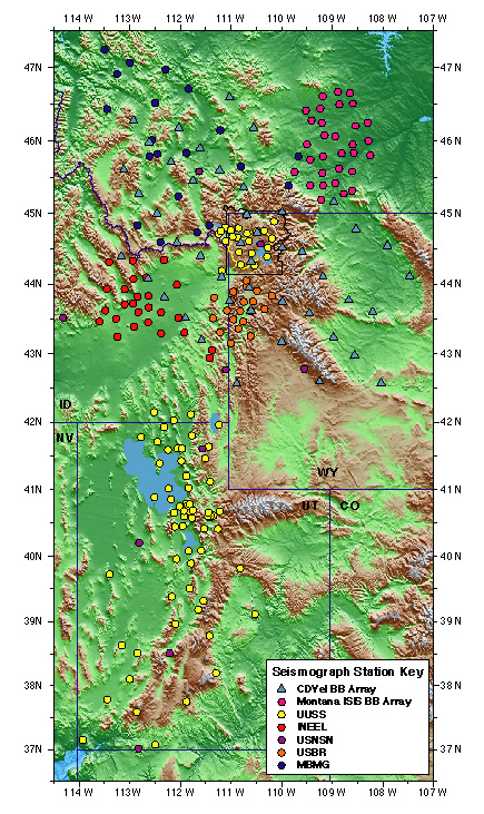
Click on the map for a 4.5 Mb PDF version which shows the station names.
The above map shows the configuration of ISIS seismographs being
recorded at the University of Utah's ORB along with the USBR's Teton Network.
The circles represent short-period vertical sensors, triangles
are short-period three component seismographs, and hexagons are broad-band
three-component seismographs. Colors correspond to the primary operators
of the stations. The Montana ISIS broad-band array has been pulled out.
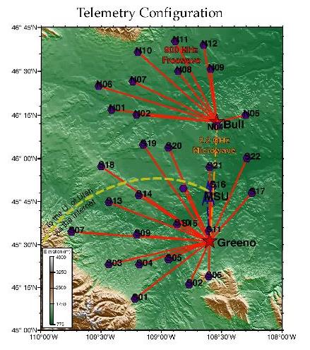
This is the telemetry configuration that was used to record the 31 station Montana array in near real time. Seismographs plotted as purple hexagons, primary collection towers, Greeno
and Bull are plotted as red stars, secondary collection tower at Montana
State University (MSU) plotted in blue.
Primary telemetry links are 1 W 908-928 MHz spread-spectrum freewave radios
(red lines). The maximum distance of these links is ~90 km. The two primary
towers are connected with each other over 46 km via microwave radio (orange
dashed line). The 18 km link between Greeno tower and MSU is also made
with microwave radio (blue dashed line). At MSU the data are ported to
the University of Utah over the internet.
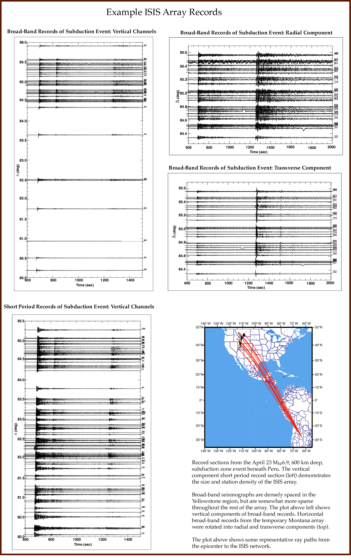
 Click here for some examples
of the data. This is a large file (905Kb).
Click here for some examples
of the data. This is a large file (905Kb).
Go to the Yellowstone Geodynamics Home Page
Go to Bob Smith's Home Page
Go to Ken Dueker's Home Page
Go to Eugene Humphreys' Home Page