Eastern Basin-Range (Wasatch Front) and Yellowstone Hotspot (Yellowstone-Snake River Plain) GPS Network (EBRY)

GPS research at the University of Utah focuses on the overall strain and deformation field of the Basin-Range province that includes Yellowstone and the track of the Yellowstone hotspot across the Snake River Plain as well as the 370 km long Wasatch fault zone.
Information on EBRY
- We process the CGPS data, with IGS precise (final) orbit, using BPE (Bernese Processing Engine) . The daily solutions of station coordinates are constrained to seven remote NGS CORS sites (ALBH, DRAO, GOLD, MDO1, NLIB, PIE1, QUIN) in an ITRF2000 reference frame.
- We estimate site velocity using ADDNEQ, a program that was developed to compute multi-session solutions from the combination of a set of single-session normal equations (.NEQ). We use an absolute-free strategy, where velocities are estimated in a stable North American reference frame by minimizing the rotation and translation transformation of seven remote NGS CORS sites (ALBH, DRAO, GOLD, MDO1, NLIB, PIE1, QUIN) onto an existing ITRF2000 coordinate system and a WUSC velocity solution.
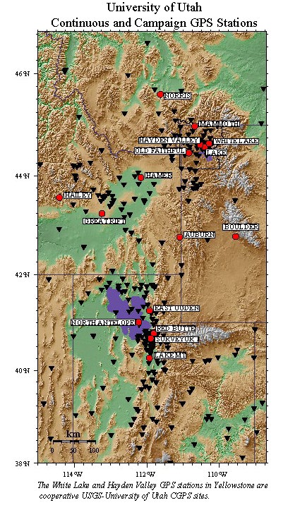
- A summary of stations in the continuous GPS network. Included are station coordinates, geologic setting, equipment used, and information on access to the sites.
I. Geodynamics of the Yellowstone Hotspot from GPS (Global Positioning System) Surveys
Objectives of the GPS component of the Yellowstone hotspot project are to measure and understand the spatial and temporal variations of the crustal deformation produced by the interaction between lithospheric plate motion and the asthenospheric hotspot. This process has produced the Yellowstone-Snake River Plain volcanic system, wide-spread uplift and subsidence of the volcanic areas, and active normal faulting of the surrounding Basin-Range province
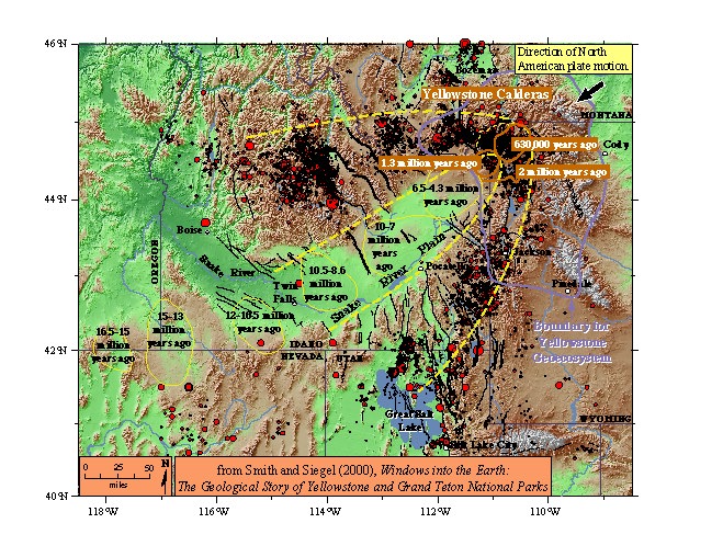
The Yellowstone-Snake River Plain volcanic system with seismicity and topography.
With a mix of campaign and continuous GPS surveys we expect to have the precision and spatial scale necessary to understand the kinematics and dynamics of the Yellowstone hotspot by: 1) integrating campaign and continuous GPS deformation data for time-dependent modeling of coupling between lithospheric and surface processes, and 2) providing data for physical models of magmatic and earthquake cycles of this region, and 3) for constraining dynamic models of the hotspot - plate interaction.
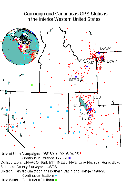
The project includes the installation and operation of 15 continuous GPS (CGPS) stations and the periodic observation of ~160 campaign GPS sites in a network of GPS stations centered on Yellowstone. Observations of the campaign sites began in 1987, and continous GPS sites began to be installed in 1996. The Yellowstone GPS network extends 400 km across the area affected by the hypothesized hotspot.
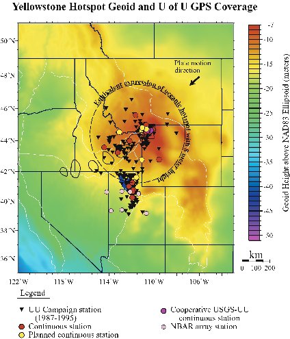
It includes parts of four western states: Wyoming, southern Montana, eastern Idaho and northern Utah. Data acquired from this project are combined to determine temporal and spatial variations in the earth's strain field as well as resolving ground velolcities in a North American framework.
Project Objectives:
1) Determine the time-dependent strain field of the Yellowstone hotspot "swell" using continuous and campaign GPS monitoring to assess the secular variation of crustal strain and to be able to correlate these results with earthquakes.
2) Develop a kinematic model for crustal deformation of the Yellowstone-Snake River Plain system constrained by ancillary earthquake, lithospheric structure, fault histories, and rheological data. We are developing a 3-D finite element time-spatial model of contemporary deformation of this region to identify areas of time-dependent loading that will be used as input to geodynamic modeling. Data from the Yellowstone and Utah GPS networks are integrated with data from other networks across the western U.S. to develop an integrated intraplate deformation model for the entire western North American plate.
GPS Logistics -- Continuous style GPS offers several improvements over campaign surveys. The first is considerably higher precision, with expected horizontal rate uncertainties of ~1 mm/yr, several times smaller than the current measured deformation rate. In addition, the continuous GPS stations yield a high level of coordinate and velocity precision with respect to the more stable North American continent. This method also provides reference frame constraints that will allow us to better resolve the broad-scale deformation associated with the Yellowstone hotspot, not as well-defined by campaign surveys. Continuous stations will also provide increased time resolution for processes observed on time scales of minutes to months. Moreover contiouous GPS provides near realtime temporal coverage of active geologic processes. However CGPS stations are more costly to operate and maintain than campaign GPS.
Campaign style -- GPS offers much greater spatial resolution but requires temporal sampling at periodic intervals of a few years. The single-point precision of campaign surveys is considerably less than continuous but over periods of several years becomes nearly the same as continous GPS. However, field logisitics are generally difficult and time-consuming in the mountainous terrain of the Yellowstone and Utah region.
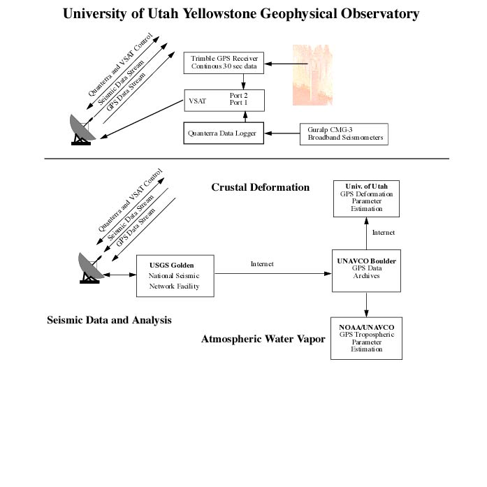
GPS Data Telemetry and Processing -- CGPS data are automatically transmitted to the Universtiy of Utah by two methods: 1) continuous streaming of 15 second sampled data via the USGS NSN satellite telemetry to Golden Colorado, where they are transmitted via the Internet to the university, and 2) at non-satellite sites the data are downloaded each day by a dial-up phone line and Internet links.
Processing GPS Data --The University of Utah currently uses the Bernese GPS Processing Engine software that is capable of providing mm-level horizontal and 1-cm level vertical positioning accuraciess over distances up to thousands of km. Data are semi-automatically processed as much as possible along with data from the Univ. of Utah Wasatch fault continuous network and selected stations from the BARGEN network with ties to Global IGS stations. Campaign data collected in 2000 were integrated into routine processing of the regional continuous data.
Research Support -- This research is sponsored by the NSF Continental Dynamics program, the USGS National Earthquake Hazards Reduction Program, the USGS Volcano Hazards Program, and the Idaho National Environmental and Engineering Laboratory with the assistance of the National Park Service. The UNAVCO facilty assists with technical aspects of these projects. For information on these data and related research projects that sponsor them, please contact Bob Smith at the University of Utah at: rbsmith@mines.utah.edu.
II. GPS Measurements, Fault Modeling and Integrated Earthquake Hazard Assessement of the Wasatch Front, Utah
Objectives of the GPS component of the Wasatch fault, Utah, project are to measure and understand the spatial and temporal variations of the crustal deformation accompaning earthquakes on the 370-km long Wasatch fault and surrounding faults of central and northern Utah. We employ a combination of campaign and continuous GPS surveys which provides the precision and spatial scale necessary to understand the kinematics of the fault-related deformation. Our efforts focus on determining the full earthquake hazards by combining the historical seismic record, the paleoearthquake history, and the GPS-determined contemporary strain field.
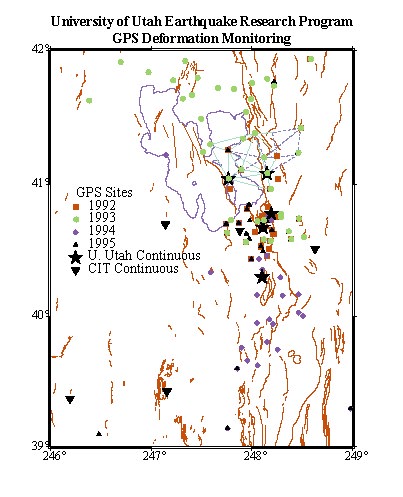
The project includes the installation and operation of 4 (a fifth station was removed because of secular variation) continuous GPS (CGPS) stations, collaborative processing of 5 BARGEN stations, and the periodic observation of ~90 campaign GPS sites in a network of stations centered on a 75 km-wide array extending from along the length of the Wasatch fault with baseline coverage across the Hansel Valley, East Cache, Oquirrh, and other nearby faults. Observations of the campaign sites began in 1993 and continuous GPS sites began to be installed in 1998. Data acquired from this project are combined to determine temporal and spatial variations in the earth's strain field as well as resolving ground velocities in a North American framework.
Project Objectives:
1) Determine the time-dependent strain field of the Wasatch and related faults by continuous and campaign GPS monitoring necessary to assess the secular variation of crustal strain and long term fault stress loading.
2) We are particularly interested in the long term behavior of the seismic cycle of the Wastach fault and how the contemporary strain field may be loading the fault.
3) Develop a kinematic model for viscoelastic behavoir of the Wasatch fault, including how prehistoric earthquakes may have affected the current stress state, and how the paleoearthquake records can be used to assess the long- vs. short-term loading rates as necessary input for earthquake assessments. We have developed both elastic and viscoelastic analytic modeling methods for modeling the contemporary deformation of this region. Data from the Utah GPS networks are integrated with data from other networks across the western U.S. to develop an integrated intraplate deformation model for the entire western North American plate.
4) To develop an integrated probabilistic earthquake hazard assessment of the Wasatch fault incorporating all of the potential sources of information on fault loading including: 1) a new analysis of paleoearthquake fault slip rates, 2) the historic seismicity rates, and 3) the contemporary strain field deduced from GPS measurments. We are also developing the analysis of the long-term loading rates from prehistoric earthquakes to assess their effects on contemporary loading rates.
GPS Logistics -- Continuous GPS offers several improvements over campaign surveys, which are
the same as given for the section above. In particular, for low stressing rate tectonic regimes such as
the Basin and Range, continuous GPS measurements are a preferred mode of operation because of the longer
time it takes to have high enough precision. However, campaign GPS surveys are necessary to resolve the
3-D distribution of strain across such a large area as the Wasatch Front. With campaign data begining in
1992 we now have a sufficient time history from campaign surveys to resolve lateral variations of strain
across different sections of the Wasatch fault.
Campaign style -- GPS offers much greater spatial resolution but requires temporal sampling at periodic intervals of a few years. The resolution of campaign surveys, while considerably less than continuous over periods of a few years, has now become nearly the same as continuous GPS for the Wasatch fault surveys.
CGPS Data Telemetry and Processing -- CGPS data are automatically transmitted to the Universtiy of Utah by continuous streaming of 15 second sampled data via spread spectrum digital radio links.
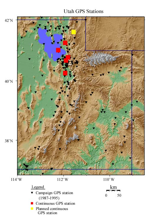
See a map of the CGPS stations
Find out about CGPS processing
Processing GPS Data --The University of Utah currently uses the Bernese GPS Processing Engine software. Data are semi-automatically processed as much as possible along with data from the Univ. of Utah Wasatch fault continuous network and selected stations from the BARGEN network with ties to Global IGS stations. Campaign data collected in 2000 were integrated into routine processing of the regional continuous data.
Research Support -- This research is sponsored by the USGS National Earthquake Hazards Reduction Program. The UNAVCO facilty assists with technical aspects of these projects. For information on these data and related research projects that sponsor them, please contact Bob Smith at the University of Utah at: rbsmith@mines.utah.edu.
III. Permanent GPS Stations

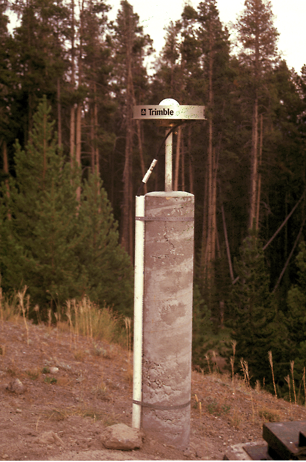
Yellowstone caldera monitoring station at Lake, Wyoming
Beginning in 1997, continuously recording GPS stations were installed by the University Of Utah to augment our field campaign sites. Eight Trimble SSI receivers with Dorne Margolin antennas were acquired with funds from the NSF Academic Research Instrumentation program in cooperation with UNAVCO, and with the University of Utah providing matching funds. Two stations in Yellowstone, White Lake, and Hayden Valley, were installed by the USGS and processed cooperatively with the University of Utah. A complete list of stations can be found here.
The initial permanent GPS was installed at Lake, Wyoming, in the Yellowstone caldera with real-time data transmission via the USGS National Seismic Network satellite link to Golden, Colorado, and then by internet to UNAVCO and the University of Utah.
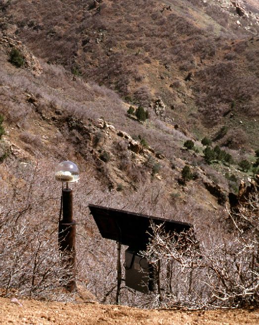
All of our permanent GPS sites are on bedrock, and our monuments are economically designed to cost about $5 to $10k per site.
A description of our permanent GPS site at Red Butte Canyon is shown here . The Lake Mountain site is shown here. Look at a photo of the East Ogden station here.
A. Yellowstone Caldera and hotspot monitoring
The initial permanent GPS station was installed at Lake, Wyoming, in the Yellowstone caldera with real-time data transmission via the USGS National Seismic Network satellite link to Golden, Colorado and then by internet to UNAVCO and the University of Utah. The data are archived at UNAVCO. This site was installed with NSF support collaboratively with the USGS.
In 1998 two permanent GPS sites were installed at the perimeter of the Yellowstone hotspot track in the eastern Snake River Plain of eastern Idaho in support of a new study of the geodynamics of the Yellowstone hotspot. An additional site was installed at Boulder, Wyoming, to serve as a stable base station.
Another continuous permanent site was established at Mammoth, Wyoming to provide base station coverage for monitoring of the Yellowstone caldera. The station was provided by the University of Utah and its operation is supported by the USGS Volcano Hazards Program.
B. Wasatch fault monitoring
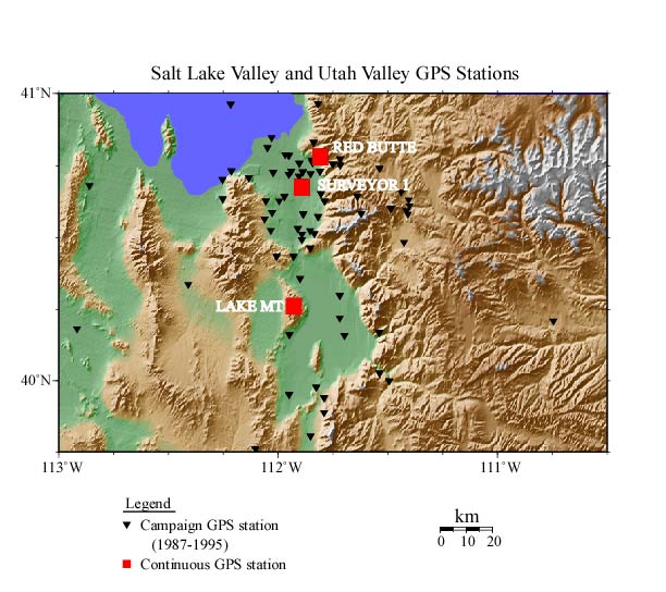
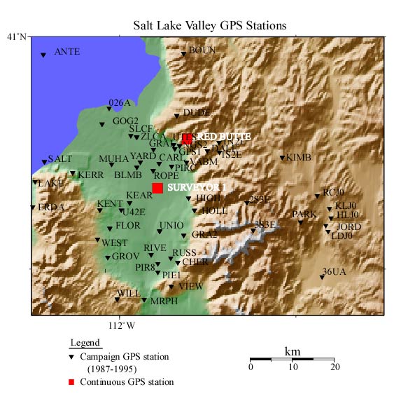
Five continuous recording GPS sites were installed on the Wasatch Front from 1997 to 1998 with support from the USGS National Earthquake Hazards Reduction Program. Data from these sites are telemetered via digital radio links to the University of Utah campus for processing. The data are archived at UNAVCO. Station Red Butte is part of the NGS CORS network.
C. Permanent Network Stations
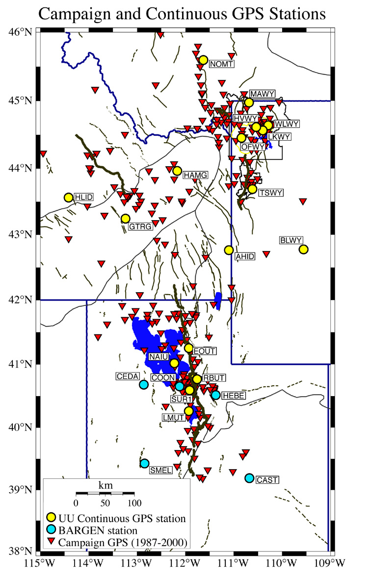
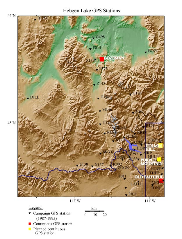
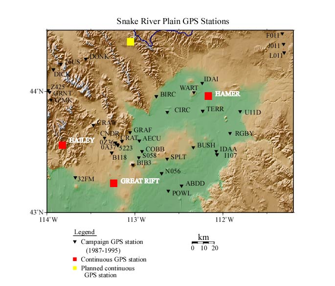
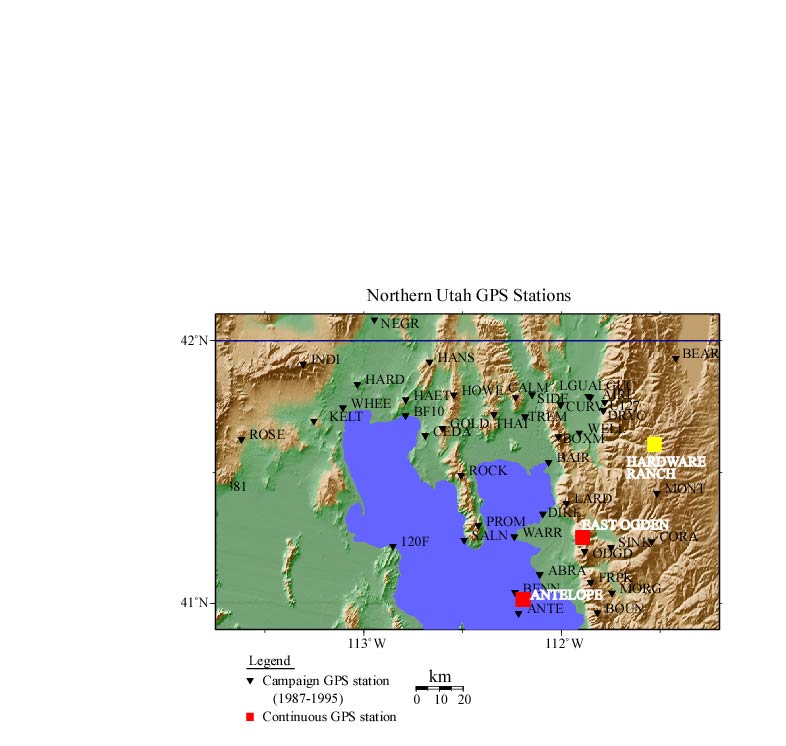
The locations of the permanent stations can be viewed on the maps. The coordinates of the stations are listed in these tables.
IV. Campaign GPS Surveys
In this document we provide maps and lists and coordinates of stations that have been surveyed in field campaigns since 1987 by the University of Utah. Our research relating to these observations is given for Yellowstone-Snake River Plain and Utah separately.
A. Yellowstone Hotspot and Yellowstone Caldera
In the Yellowstone hotspot project, campaign surveys have been made in 1987, 1991, 1993, 1995, and 2000. See complete table of University of Utah GPS stations or Idaho-Montana-Wyoming stations or Utah stations. For each survey, GPS data were observed on existing benchmarks primarily around Yellowstone, while in Yellowstone many new GPS marks were set by the NGS. Remote sites consisted of existing USGS benchmarks and marks set by the University of Utah.
A total of 274 stations have been observed in five field campaigns that included cooperative support from the National Geodetic Survey and MIT. This project was supported by the NSF Geophysics program. See our research results here.
In 1995 an additional 50 GPS sites were occupied around the Yellowstone hotspot in order to focus on the Snake River Plain (the track of the hotspot) and in order to map laterally the plausible extent of the hypothesized plume head in the lithosphere.
B. Wasatch Front, Utah
In 1992, 1993, 1994, 1995, and 2000 GPS surveys were made to provide baseline coverage across the Wasatch fault as part of an earthquake surveillance program and earthquake hazards evaluation. See table of station occupations. This project was supported primarily by the USGS National Earthquake Hazards Program with collaborative support from the Utah Geological Survey, the BLM, and surveyors from Salt Lake, Weber, Davis, Utah, Cache, and Box Elder counties. A total of 90 stations have been surveyed in this project, mostly occupying existing NGS, USGS, and other geodetic monuments.
Research on earthquake hazards of the Wasatch fault are reported here and is one of the research projects of the University of Utah Seismograph Stations.
V. GPS Data Archives
GPS campaign and continuous data from the University of Utah projects are archived at the University NAVSTAR Consortium (UNAVCO) gps data archives. Raw GPS data, RINEX (ascii common exchange format) files, and copies of field logs are available upon request from UNAVCO. Please see the links to individual campaigns listed by year below. The links summarize the campaigns, and the data can be obtained by choosing "Data Request" from the menu at the bottom of the linked page.
Yellowstone
1987 06 (June)
Yellowstone 1989
Yellowstone/Hebgen Lake 1991
Wasatch Fault 1992
Yellowstone/Wasatch Fault 1993
Wasatch Fault 1994
Yellowstone/Wasatch Fault 1995
Wasatch Fault 1999
Yellowstone/Snake River Plain 2000
The permanent station network is ongoing and a data summary can
be found at:
University
of Utah GPS Network
EOUT-East Ogden, Utah - East of Ogden, Utah.
LMUT-Lake Mountain, Utah County - west side of Utah Lake.
NAIU-North Antelope Island, Utah.
RBUT-Red Butte Canyon, near the University of Utah campus.
SUR1-Surveyor 1, Salt Lake County surveyors site, Salt Lake County.
Yellowstone
Hotspot GPS Network
AHID-Auburn Hatchery, Idaho West of Afton, Wyoming. Co-located
with a USGS National Seismic Net Station.
BLWY-Boulder, Wyoming. Co-located with a USGS National Seismic Net Station.
GTRG-Great Rift, Idaho. North of Craters of the Moon National
Monument, Snake River Plain.
HAMG-Hamer, Idaho. Northwest of Idaho Falls.
HVWY-Hayden Valley, Yellowstone NP.
HLID-Hailey Idaho, Near Sun Valley Idaho. Co-located with a
USGS National Seismic Net Station.
LKWY-Lake, Near Lake Jct Yellowstone NP. Co-located with a USGS
National Seismic Net Station.
MAWY- Mammoth, Headquarters, Yellowstone NP.
NOMT-Norris Montana. West of Bozeman Montana. Co-located with a
USGS National Seismic Net Station.
OFWY-Old Faithful, Yellowstone NP.
TSWY-Tetons Science School, Wyoming. East side of Grand Teton National Park, Wyoming.
WLWY-White Lake, Yellowstone NP.
Yellowstone
Caldera Network
LKWY-Lake, Near Lake Jct Yellowstone NP. Co-located with a USGS
National Seismic Net Station.
MAWY- Mammoth, Headquarters, Yellowstone NP.
OFWY-Old Faithful, Yellowstone NP.
UNAVCO also has an ftp area for which includes recent permanent station RINEX files from the Utah/Idaho/Wyoming stations. Data are organized here by yyyy/day and then by conventional rinex file name at ftp://data-out.unavco.org/pub/rinex
VI. GPS Data Processing
The University of Utah uses the Bernese GPS processing software, which is capable of providing mm-level horizontal and 1-cm level vertical positioning accuracies over distances up to thousands of km (Rothacher and others, 1994). The addition of the Bernese Processing Engine (BPE) allows us to process large volumes of continuous data from our permanent stations in Utah, Idaho, and Wyoming to high accuracy with minimal operator interaction. In order to establish our reference frame in a global system, we make ties to regional continuous stations which contribute to the International GPS Service (IGS). IGS stations have coordinates and velocities published in the International Terrestrial Reference Frame (ITRF-96). We process the data with loose constraints to IGS stations with ITRF-96 coordinates, then combine solution (ADDNEQ/SINEX) files periodically to determine our station coordinates and velocities. For precise orbits, we use the IGS combined orbit solutions available from the IGS central bureau. One of our currently operating stations, RBUT (Red Butte canyon, Utah) and a former station SUR1 (Surveyor One in the Salt Lake valley, are also submitted to the National Geodetic Survey (NGS) as part of the CORS network. Official NAD-83 survey coordinates for these sites can be obtained from NGS.
Campaign processing has been done in a slightly different manner.The GPS data for the Yellowstone and Utah survey campaigns were processed using station single-differences with respect to a local station we operated continuously during each survey. The approximate position of this station was determined at only the centimeter-level with respect to North American tracking sites. A limitation of campaign-style episodic surveys is that survey results, while precise enough to define local relative velocities, are not sufficient to define motion in a broad-scale regional sense. This is partially due to the shorter times of surveys, and the limited data from regional tracking stations and quality of post-fit orbits available between 1987-1992. Campaign results have for this reason been “Inner Coordinate” solutions capable of accurately showing how a region is internally deforming, but not able to resolve mm/yr level motions with respect to stable North America. The University of Utah's permanent station network was established to give greater precision which will allow us over time to determine mm-level motions with respect to stations ~1000 km away in stable North America.
Additional links to GPS processing-related sites:
VIII. Links to Related GPS Research Projects in our Study Areas
IX. People Involved in the University of Utah GPS Projects
Robert B. Smith and Charles M. Meertens, Principal Investigators, with major contributions from Christine Puskas, Dave Drobek, Wu-Lung Chang, and Theresa VanHove (UNAVCO).
X. Agencies Supporting University of Utah GPS Research
The GPS related research projects at the University of Utah are supported by the National Science Foundation Academic Research Instrumentation with matching financial support for purchase of GPS receivers by the University of Utah. GPS research has been supported by the NSF, EAR Continental Dynamics Program and the EAR Geophysics Programs for research on the Yellowstone hotspot. The U.S. Geological Survey, National Earthquake Hazards Reduction Program, and the Volcano Hazards Program supports research on the Wasatch fault and in Yellowstone National Park, respectively. GPS work in Yellowstone National Park is in cooperation with the National Park Service. The Idaho National Environmental and Engineering Laboratory partially supports the operation of continous GPS stations on the eastern Snake River Plain. UNAVCO (University NAVSTAR Consortium for GPS research and operations) has assisted with data processing, data archiving, field campaigns, and continous GPS station installation.
Email Bob Smith at
rbsmith@mines.utah.edu
with any suggestions or questions on this web page.