Yellowstone Hotspot |
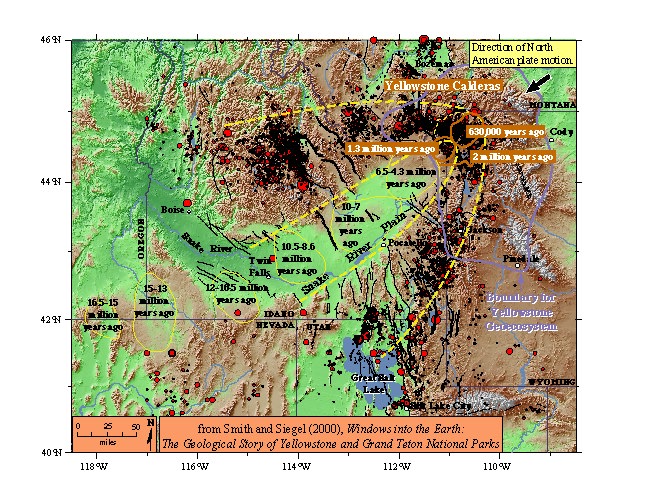
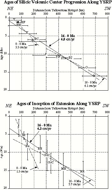
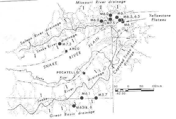
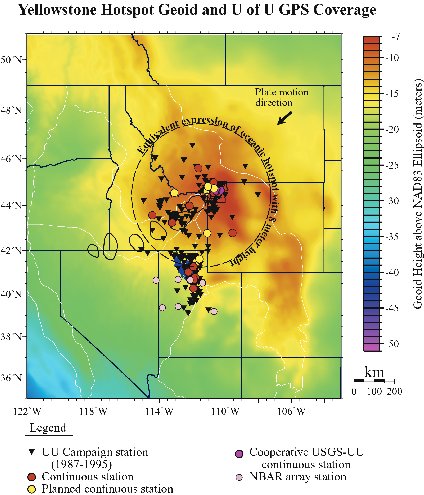
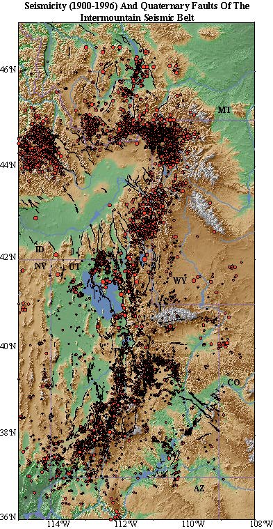
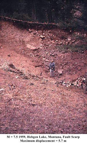
Track Of The HotspotThe volcanic history of the Yellowstone-Snake River Plain volcanic field is based on the systematic time-progressive volcanic origin of this region that is characterized by several large calderas in eastern Snake River Plain with dimensions similar to those of Yellowstone's three giant Pleistocene calderas. These volcanic centers are located within the topographic depression that encompasses the Snake River drainage and is surrounded by topographically high shoulders on its east and west sides. Age Progression Of YSRP Silicic Volcanic CentersThe systematic age progression of the volcanic centers provides the best direct evidence for systematic motion of the North American plate across a mantle magmatic source that first noted by Jason Morgan (1972), who calculated a southwest-trending vector for the North American plate of 1 - 2 cm/yr from a hypothesized plume beneath Yellowstone with a track along the Snake River Plain. The youngest silicic volcanic centers correspond to the Yellowstone volcanic field that are less than 2.0 Ma and are followed by a sequence of silicic centers at about 6 Ma, southwest of Yellowstone. A third group, near ~10 Ma, is centered near Pocatello, Idaho. The oldest mapped silicic rocks of the SRP are ~16 Ma, are distributed across a 150 km-wide zone in southwestern Idaho and northern Nevada, the suspected origin of the YSRP. Smith and Braile (1994) calculated a 4 cm/yr rate for the silicic age progression by fitting a linear regression of silicic volcanic ages and location along the YSRP. Their analysis shows an average rate of silicic age progression of 4.5 cm/yr for 20 - 0 Ma but they distinguish two regimes: 1) for the 0 - 8 Ma period, they determined a rate of 3.3 cm/yr, and 2) for the 16 - 8 Ma period, with a calculate a rate of 6.1 cm/yr. An important factor not incorporated into previous estimates of Yellowstone plate motion is the effect of concomitant crustal extension associated with the Basin-Range extension of ~0.5 to 1 cm/yr. for an integrated rate of ~3 cm/yr. The Yellowstone-Snake River Plain Tectonic Parabolatectonic parabola. The systematic topographic features of the eastern SRP have been suggested as the result of general topographic collapse of the eastern Snake River Plain (Smith and others, 1985) and Smith and Braile (1994) in their assessments of the seismotectonics of the Yellowstone hotspot, by Anders and others (1989, 1992) who ascribed the systematic parabolic-shaped topography of the YSRP to the Yellowstone hotspot, and by Pierce and Morgan (1990, 1992) who attruibuted the topography and fault patterns of this region also to the Yellowstone hotspot.Lithospheric deformation on the scale of Yellowstone's hotspot is associated with large-scale mantle processes generally have an observable response in river drainage systems. The resulting deformation of the topography reveals the high topographic divides surrounding the SRP which separate the Snake River and the Salmon River drainages to the northwest and the Great Basin and ancestral Snake River drainages to the southeast. The highest elevations are associated with the topographic divides at 1,500 to 2,000 m in elevation and the bordering topographic shoulders extend southwestward from Yellowstone for 400 km wrapping around the SRP in the characteristic parabolic pattern. Also plotted are the locations of the larger, Ms > 5.7, earthquakes of the region that demonstrates an important observation, namely that the background seismicity is generally located in the areas of the SRP drainage divides (except for the 1983 Borah Peak nucleation point which is 25 km southeast, but its surface rupture extends northwest beyond the drainage divide). This correlation suggests a common mechanism for the topography and seismicity which is believed to be related to the Yellowstone hotspot and its interaction with an overriding lithospheric plate. Geoid ResponseThe long-wavelength topographic response of the Yellowstone hotspot can be compared with oceanic hotspots such as the Cape Verde, Galapagos, Azores and Hawaiian islands. These classic oceanic hotspot signatures range from 1 to 2 km above the abyssal plain and their widths range from 700 km to 1,500 km. These compare with the 600-km-wide topographic anomaly and the ~1000 km wide geoid anomaly of Yellowstone is similar to those associated with oceanic swells and hotspots and provides corroborative evidence for a mantle origin of Yellowstone.An interpretation of the geoid is that is considered a representation of the degree of isostatic compensation and is an equipotential surface reflecting an amalgam of topographic relief and density variation. Most of the local geoid features are due to topographic variation and density variations form a secondary, but important source of the geoid anomaly. The Yellowstone geoid anomaly is the most significant anomaly of the entire North American continent. It is very broad, ~1,000 km wide, 10 to 12 m, circular geoid high centered at Yellowstone is thought to reflects the anomalous ~600 m high excess topography of the Yellowstone Plateau, with a superimposed long wavelength geoid signal produced by a large upper mantle low-density body associated with the mantle hotspot. Note that the radius of this anomaly is similar to the radii of geoid anomalies associated with oceanic swells and rises which range from ~800 to 1,500 km and average 10-15 m in amplitude reflecting the effects of buoyancy and lateral flow of the upper-mantle spreading out from a plate-plume interaction at Yellowstone with source dimensions of ~150 km. Patterns of Quaternary FaultingThe style of Late Cenozoic normal faulting of the YSRP and its related deformational patterns is seen in the YSRP topography-fault figure, at the top of the page. Smith and Braile (1994) noted areas of similar-aged faulting and distinct seismicity that they designated as zones II and III. Zone I corresponds to the generally undeformed and seismically quiescent SRP volcanic field. Zone II extends outward ~80 km from the boundaries of the SRP and is characterized by faults whose most recent displacements are generally older than post-glacial, i.e., generally greater than ~14,000 years to Late Cenozoic age (marked by thin lines). Zone II was suggested by Smith and others (1985) as possibly related to a thermal shoulder of the Yellowstone hotspot, while zone III encompasses the active earthquake zones surrounding the SRP and appears to have been much more active throughout Holocene and historic time than those in zone II. Note those faults that have ruptured in historic time are generally within zone III and are indicated by bold red lines on the figures above.Regional SeismicityThe dual-sided pattern of seismicity surrounding the YSRP is apparent in the seismicity map of the Intermountain region, most notably following the 1983 Borah Peak earthquake and is described in detail by Smith and Arabasz (1991). This area is marked by the occurrence of the two largest historic earthquakes in the Intermountain region: 1) the Ms = 7.5, 1959 Hebgen Lake, Montana, and 2) the Ms = 7.3, 1983 Borah Peak, Idaho, earthquakes. In contrast, the SRP is seismically quiescent at the magnitude 2+ level. Beginning at the southern margin of the YSRP, earthquakes near the Utah- Idaho border occur near the change in direction between the southern and central parts of the ISB. North of the Utah border there is a notable change between the northeast-trending seismicity belt and northwest- trending zones of late Cenozoic normal faulting that we believe reflects the influence of the Yellowstone hotspot. Seismicity of the Idaho-Wyoming border area, encompassing the Teton region, reveals a scattered northeast trend, approximately parallel to the SRP, that continues into the southern Yellowstone Plateau, but with a notable gap in historical seismicity along the Teton fault. Earthquakes continue north across a ~100 km wide, north- trending zone, intersecting the caldera in the vicinity of Yellowstone Lake. Within Yellowstone, widespread earthquake swarms characterize the caldera with a distinct change in regional trend from north-south at the southern Yellowstone Plateau, to northwest on the northwest margin of the caldera. West of the Yellowstone caldera, a pronounced east-west band of earthquakes passes through the Hebgen Lake, Montana, region, including the epicenter of the Ms = 7.5, 1959 Hebgen Lake earthquake that occurred about 30 km west of the caldera. This earthquake produced a 26-km-long west- to northwest-trending rupture with a maximum vertical displacement variously cited as 5.5 to 6.7 m (see Smith and Arabasz, 1991). Earthquakes in this area are part of the divergent belt of seismicity that extends more than 400 km along the west side of the SRP in a west-southwest direction into central Idaho. Southwest along the northwest side of the SRP, the earthquake patterns reveal a northwest alignment of epicenters that corresponds to mainshock and aftershocks of the MS = 7.3, 1983 Borah Peak, Idaho, earthquake, the second-largest historical earthquake in the Intermountain region. This large scarp-forming earthquake was accompanied by a 34-km long fault with up to 2.7 m of co-seismic vertical slip and occurred 60 km northwest of the Snake River Plain in an area characterized by Late Quaternary Basin-Range faulting but of low background seismicity prior to this large earthquake. Before I conclude this discussion, it is important to comment on the origin of the of the Oligocene, Columbia Plateau basalt field of western Oregon and Washington that has been attributed to the same mantle plume source as the Yellowstone hotspot. While there is no systematic time progression of the Columbia Plateau basalts, the immense scale and synchroneity of timing of this volcanic field suggests a similar mantle source for both Yellowstone and the Columbia basalts. | |
|
|
II. Yellowstone's Volcanic History |
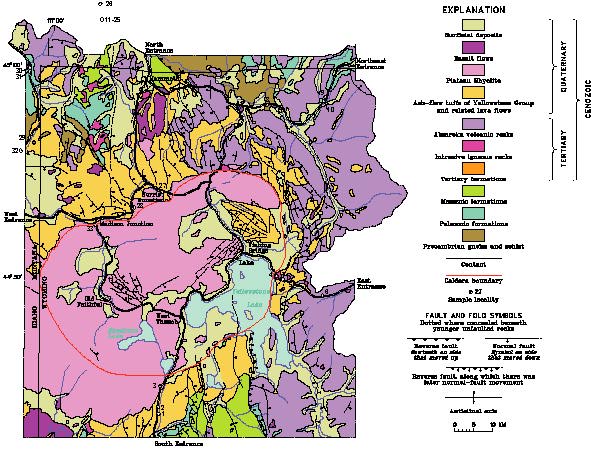
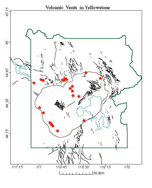
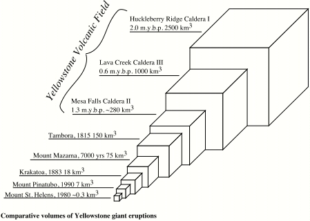
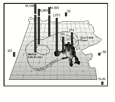
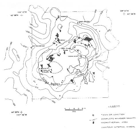
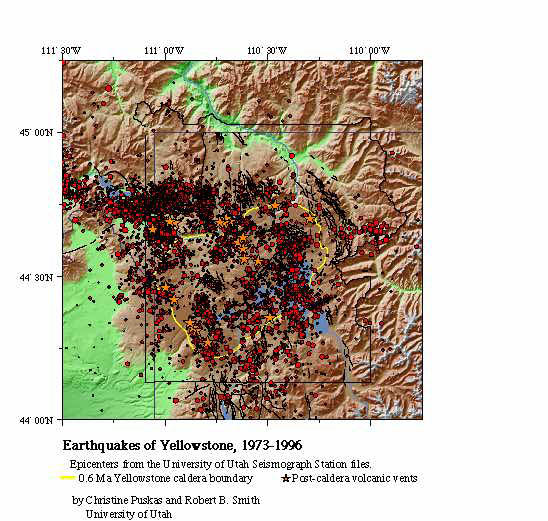
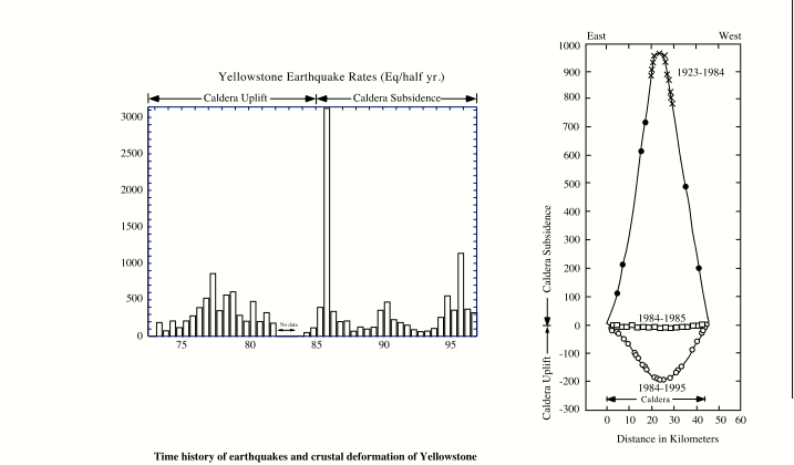
Yellowstone VolcanismVolcanic History of YellowstoneThe earliest scientific account of Yellowstone's volcanism and earthquakes was given by Hayden (1872, 1873) based on his late 19th century, pioneering field expeditions into Yellowstone. Hayden recognized that Yellowstone region was the center of a giant volcanic system and remarked on the occurrence of numerous small to moderate magnitude earthquakes. Geologic studies by various U. S. Geological Survey and university scientists continued through the early 20th century to the present and interest in the region was heightened by the occurrence of the 1959, Ms = 7.5, Hebgen Lake, Montana, earthquake, the largest earthquake in the Intermountain region in historic time. Following this earthquake, investigations led to an elucidation of the cyclic nature and a recognition of the immense scale of Yellowstone's explosive Pleistocene volcanism dominated by three catastrophic, caldera-forming eruptions which produced more than ~4,800 km³ of ash flows at 2.0 Ma, 1.2 Ma, and 0.6 Ma, according to studies of Yellowstone by U. S. Geological Survey geologists. The most comprehensive treatment of Yellowstone's volcanic history is from the work of Christiansen and Blank (1972), Christiansen (1984), and Christiansen's (1998) forthcoming U. S. Geological Survey Professional Paper. These studies outlined the first cycle of Yellowstone's cataclysmic silicic volcanism, which produced the Huckleberry Ridge tuff, occurred at 2.0 Ma (denoted as I) and produced a large caldera that is now mostly covered by younger volcanic flows with an total eruptive volume of 2,500 km³. The second cycle, Henry's Fork caldera (denoted as II) was restricted to the Island Park area, southwest of the Yellowstone Plateau, and produced 280 km³ of ash flow. Following the 0.6 Ma caldera-forming eruption of 1,000 km³ (denoted as III), drainage of a large magma chamber removed roof support, causing it to collapse and produce the 45 km wide by 75 km long "Yellowstone caldera." Since the last caldera-forming eruption, 600,000 Ma, there have been an 30 or more silicic volcanic eruptions on the Yellowstone Plateau. The cumulative effects of the post-caldera eruptions have produced the gently rolling and forested topography of the Yellowstone Plateau. Following caldera collapse at 0.6 Ma, magmatic resurgence formed two structural domes: 1) the Sour Creek dome in the northeast caldera began its uplift following the main eruption at 0.6 Ma, and 2) the Mallard Lake dome in the southern caldera was initiated at 0.15 Ma. Both of these domes are thought to have been produced by uplift above magmatic sources and are considered to be active volcanic features. Following the explosive eruption of the 0.6 Ma Yellowstone caldera, the caldera dropped several hundred meters, producing a subsided floor that was later filled by post-caldera flows and lake sediments. The Quaternary tectonics of the Yellowstone Plateau is dominated by normal faulting and crustal extension associated with general Basin-Range epeirogeny. The main Quaternary faults of the Yellowstone Plateau are the Gallatin, Madison, and Teton fault zones of Late Tertiary age. The Gallatin and Madison fault zones on the northern plateau margin and the Teton fault zone on the southern margin all trend north-south. Buried extensions of these faults may exist in areas covered by the Quaternary silicic volcanic rocks. Quaternary Faults of YellowstoneLate Quaternary faults extend along the west side of the South Arm of Yellowstone Lake in an area of prominent seismicity. On the northwest side of the Plateau, the seismically active Hebgen Lake fault zone extends ~30 km east-southeast toward the caldera boundary, but its relationship to the rim boundary fault is not known. The relationship of the north-south trending Gallatin fault, which extends south of Mammoth and terminates at the northwest caldera, is also not well known because of limited accessibility and extensive cover. On a map of Yellowstone faults we have also plotted the locations of post-caldera volcanic vents that fed the <630,000 Ma caldera flows. The vents form two distinct groups: 1) a northwest alignment in the southwest Yellowstone caldera, and 2) a similar north- to northwest alignment in the northwest caldera that project into a series of west- to northwest-trending Quaternary faults near Norris Junction. On the basis of contemporary seismicity I believe that the vents southeast of Norris Junction are related to an active fault system that may continue southeasterly beneath the central caldera. Global Significance Of Yellowstone¹s Explosive VolcanismTo portray the importance of Yellowstone's volcanism, the eruptive volumes of several well-known historic volcanic eruptions of global significance along with those of Yellowstone are plotted here. The smallest eruption in this comparison was that in 1980 at Mt. St. Helens, Washington. While this volcano produced substantial destruction and ash that covered areas of several surrounding states, its eruptive volume is thought to be ~0.3 km³. The 1991 eruption of Mt. Pinatubo, Philippines, killed more than 600 persons and expelled 10 km³ of ash. (It is interesting that another major volcanic eruption of North America was that of the 6.8 Ka Mazama volcano, which ejected 75 km³ of ash and was responsible for producing a high mountain lake and the focus of Crater Lake National Park, Oregon.) The next largest eruption was that of Krakatoa, southwest Pacific, which expelled more than 18 km³ in 1883. The even larger Tambora, Indonesia, eruption of 1815 produced 150 km³. However, none of these eruptions comes even close to the smallest of Yellowstone's Pleistocene caldera-forming explosive eruptions. Yellowstone's climactic eruptions expelled ash flows with volumes of: 1) 2,500 km³ with 2.0 Ma Huckleberry Ridge tuff , 2) 280 km³ in the 1.2 Ma Mesa Falls tuff, and 3) 1,000 km³ with the 0.6 Ma Lava Creek tuff (Christiansen, 1984). Continuous small-scale rhyolitic and basaltic eruptions between the climatic events contributed an additional 3,500 km³ of ash flows for a total of ~8,000 km³. These volumes make Yellowstone one the world's largest, if not the largest, known center of active silicic volcanism. To further portray the scale of Yellowstone's silicic volcanism, the areas covered by ash deposits from four large eruptions of the western U. S. are plotted here from USGS mapping by Robert L. Christiansen and colleagues, published by Keefer (USGS Bulletin 1347, 1975). These include: 1) the 0.74 Ma Bishop tuff with 500 km³ of ashes from the Long Valley, caldera, California, 2) the 0.6 Ma Lava Creek tuff of Yellowstone, 3) the 2 Ma Huckleberry Ridge tuff of Yellowstone, and 4) 1980 Mt. St. Helens volcano, Washington. The significance of these eruptions is evident by the immense areas of ash coverage, from thicknesses of a few millimeters to several meters, that blanketed much of western North America. For example the Bishop tuff covered most of the southwestern U. S. and northern Mexico. Ash from Yellowstone's Huckleberry Ridge and Lava Creek tuffs, however, covered the entire western U. S., much of the midwest, parts of the eastern Pacific, and northern Mexico. Compared to the ash fall coverage of Mt. St. Helens, which had such a dramatic effect on the landscape and the population of western Washington and Oregon, the scale of Yellowstone's prehistoric caldera-forming eruptions are immense. And while the Mt. Pinatubo and Mt. St. Helens eruptions had disastrous effects, they are very small compared to Yellowstone's past and future potential for catastrophic, caldera-forming eruptions. What's Happening At YellowstonePhysical Properties of YellowstoneHeat FlowThere is a single physical property that sets Yellowstone apart from virtually all other continental regions, namely its extremely high heat flow of ~2,000 mWm-2, which is about 30 times the continental average. Not only is heat an essential property of the youthful volcanism and hydrothermal activity of Yellowstone, we believe it drives such important mechanisms as thermal buoyancy which affects the topography and the distribution of earthquakes of the YSRP system.The regional heat flow of the Snake River Plain ranges from 40 to 100 mWm-2, while the Beartooth and Absaroka Mountains have values from 50 to 80 mWm-2. There is also a clear distinction between the high heat flow of Yellowstone (2,000 mWm-2) and that of the Basin-Range (75 to 90 mWm-2), with transitional values of ~100 mWm-2 within the Snake River Plain and much lower values of 50 to 80 mWm-2 north and east of the YSRP. The significance of Yellowstone's heat flow on a global scale can also be seen by comparing its 2,000 mWm-2 flux with that of the background heat flow of the North American continent of 40 to 60 mWm-2. The thermal energy release of Yellowstone is of the same order as such large volcanic features as the entire Cascade Range, the Columbia Plateau, and the ignimbrite fields of the Basin-Range. Moreover, it is 2 to 3 times the greater than that of the Valles, New Mexico, and the Long Valley, California, calderas. Blackwell (1978) estimates that fully 5% of the total thermal energy of the entire U. S. Cordillera is released at Yellowstone, which occupies less than 0.1% of its area. The only conductive heat flow measurements in the Yellowstone caldera were made in Yellowstone Lake using marine-type thermal probes in shallow sub-bottom sediments by Morgan and others (1977). Their mapped values ranged from 125 - 300 mWm-2 in the southern arms of Yellowstone Lake and rapidly increased northward across the caldera boundary with an average value of 1,600 mWm-2 for the main lake basin. The convective heat flow component of Yellowstone, however, can be estimated by chemical determinations of chloride content from hot water drained through hot springs and geysers and collected in streams and rivers. Fournier (1989) and Fournier and Pitt (1985) estimated a total convective flux for the entire Yellowstone Plateau of 4x10¹⁶ cal/yr using geochemical methods that corresponds to a heat flow value of about 2,000 mWm-2.Fournier (1989) calculated that the 2,000 mWm-2 heat flux is consistent with the release of heat by crystallization and cooling of about 0.1 km³ per year of rhyolitic magma from 900°C to 500°C. We believe this is a reasonable estimate of the magmatic recharge rate for Yellowstone and is good evidence that magmas are present beneath the caldera. Regional Gravity Field YellowstoneThe YSRP Bouguer gravity field mimics the regional patterns of topography, i.e., gravity lows correspond to topographic highs, and vice versa, and we will not show it here. Yellowstone's gravity field is dominated by a -60 mGal residual low centered over the caldera, but notably extends northward ~25 km beyond the caldera, encompassing the northeastern Yellowstone Plateau. An additional localized -20 mGal low is centered in the northeastern Yellowstone Plateau, located on the north side of the Sour Creek dome and near the largest hydrothermal system in Yellowstone, the Hot Springs Basin. The negative gravity anomaly of Yellowstone thus contrasts with the pronounced positive gravity anomaly of the SRP and suggests notable differences in crustal composition. Models of the gravity anomaly of Yellowstone suggested that the surficial rhyolites were underlain by hydrothermally altered basement rocks with molten or partially melted rhyolites and basalts. Models revealed: 1) an upper 2.4-2.5 g cm-3 layer, 1-2 km thick corresponding to caldera sediment fill and rhyolite flows; 2) a 2.6-2.7 g cm-3 upper-crustal layer beneath most of the caldera which corresponds to a 10% P-wave velocity decrease and is interpreted to be a hot but generally solid, granitic of batholithic proportions; and 3) an unusually low density body of 2.40 g cm-3 at depths of 1 to ~10 km beneath the northeast caldera. The low density body of the northeast caldera corresponds to an additional ~15% velocity decrease and is consistent with models ranging from thick sediment fill to hydrothermally altered near-surface material underlain by a body dominated by hydrothermal fluids or silicic partial melts of up to 15%. Crustal StructureThe YSRP has been the focus of two major seismic refraction experiments in 1978 and 1980 (Smith and others, 1982; Braile and others, 1982). The 1978 project targeted the large-scale tectonic and volcanic features of the YSRP and the 1980 project focused on the upper-crust of the volcanically covered SRP as well as evaluating anomalous features revealed in the 1978 project. Earthquakes of YellowstoneThe historical seismicity of Yellowstone is marked by the large 1959, Hebgen Lake, Montana, Ms = 7.5 event located on the northwest margin of the caldera, its extensive aftershock sequence, and by extensive earthquake swarms within the Yellowstone caldera. Intense swarms of shallow earthquakes and occasional moderate-sized events, as large as the 1975, ML = 6.1 Norris Junction earthquake, characterize the well-defined 1973-1996 seismicity of the Yellowstone region. The general pattern of background seismicity in the northwestern caldera is oriented northwesterly parallel to northwest-trending post-caldera volcanic vents. However, seismicity varies across the caldera. Within the caldera earthquakes have not exceeded magnitude ML = 4.5, and epicenters are generally scattered, except with the alignments spatially associated with the volcanic vents. In several examples, there is a good correlation of seismicity with the onset of new hydrothermal activity (Pitt and Hutchinson, 1982). Earthquake patterns suggest seismic slip on the boundaries of small upper-crustal blocks, which may reflect a combination of deformation caused by local magma/hydrothermal fluid transport and by the regional tectonic stress field. The temporal distribution of earthquakes in Yellowstone demonstrates the importance of the long-lasting earthquake swarms. Hayden (1872) first commented on the occurrence of extensive earthquakes (swarms) during his exploration of Yellowstone in 1871, described in an earlier section. Detailed seismicity studies noted the occurrence of earthquake swarms with magnitudes as large as ML = 4.5 the early 1970s and Pitt and Hutchinson (1982) documented a major swarm with focal depths less than 5 km deep in 1978 between Yellowstone Lake and Canyon Junction which lasted for several months and coincided with major changes in hydrothermal features. The 1985 northwestern caldera swarm however, was the largest and most persistent in the historic record. Nagy and Smith (1988) documented a 6-month period of intense earthquake activity that peaked in frequency-of-occurrence with earthquakes of magnitude as large as ML ~4.5 in November and December, 1985. Focal depths for these events ranged from 3 to 10 km and the epicenters extended along a 15 km long northwest-trending zone next to the caldera boundary. Focal mechanisms for this swarm were dominated by strike-slip solutions with a common left-lateral slip nodal plane striking to the northwest and aligned with the trend of the swarm epicenters. Notably the trend of this swarm projected northwest and was orthogonal to the caldera boundary, suggesting the possibility of a radial fracture extending from the caldera and a possible scenario for either a propagating fracture extending from the Hebgen Lake fault toward the caldera or as magma filled fracture extending radially outward from the caldera. On the southeastern side of the caldera, epicenters associated with the background seismicity are aligned with north-south trending zones including epicenters near a normal fault along the west side of the Yellowstone. An alignment of epicenters in the southern Yellowstone Plateau may reflect a buried extension of the Teton fault. Focal Depth Variations And Temperatures of the Yellowstone CalderaLateral variations in focal depths of earthquakes of the Yellowstone caldera are thought to reflect variations in the depth to the brittle-ductile transition. Maximum focal depths outside the caldera are generally less than 15-20 km, but decrease to less than 5 km beneath the caldera. This distinctive shallowing suggests a thin seismogenic brittle layer above a major heat source. Within the caldera, the crust appears to be in a quasi-plastic state at depths exceeding 5 km and at temperatures greater than 350° - 450°C, incapable of supporting shear stresses. If the 80th-percentile of focal depths of the Yellowstone caldera reflects the depth to the 350°C isotherm, as hypothesized by Smith and Bruhn (1984) for extensional regimes, the temperature gradient can be estimated. The maximum focal depths occur at about 10 km outside and west of the caldera and corresponds to a thermal gradient of 35°C/km. Inside the caldera the average 80th-percentile depth at ~5 km corresponds to a gradient of 70°C/km and a corresponding conductive heat flow value of ~200 mWm-2. These data suggest that the conductive heat flow of the caldera of ~200 mWm-2, which is ~10 times smaller than the total heat flux of the caldera of ~2,000 mWm-2 and thus requires a convective heat transfer of ~ 1,800 mWm-2. The ratio of conductive to convective heat flux provides a measure of the relative magnitude of thermal convective heat transport as specified by the Nusselt number which is defined as the ratio of the convective to conductive heat flow. For Yellowstone, a Nusselt number of 10 compares with Nusselt numbers calculated by the same method for 0.7 Ma Long Valley caldera, California, of 6 to 8. Crustal Deformation, 1923-1995While subsidence of the Snake River Plain over its 16 Ma history reflects the long-term deformation pattern of that region, the Yellowstone Plateau has been the site of unprecedented crustal deformation in historic time that is characterized by a ~56 year period of caldera-wide uplift totalling about 1 m, then a sudden reversal to subsidence in 1985 that continues to the present, 1997. This signature, along with the intense seismicity, is perhaps the most important paramter that reflects the presence of hydrothermal fluids and magma beneath the Yellowstone caldera.
| |
|
|