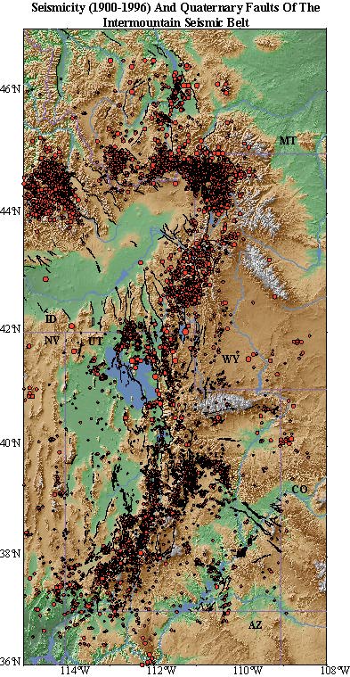
Utah occupies the southern part of the Intermountain Seismic Belt with more than 80% of Utah's population of 2 million concentrated on or near the Wasatch fault. However, despite its extensive prehistoric seismicity, the Wasatch fault has been relatively dormant in historic time.
Because of the population density adjacent to the Wasatch fault, this area is a major focus of our research, which includes studies of prehistoric earthquakes, GPS monitoring, earthquake hazard assessment, examining fault interaction, and correlation of earthquakes with faulting and probabilistic risk.
Contemporary Deformation Of The Wasatch Fault From GPS
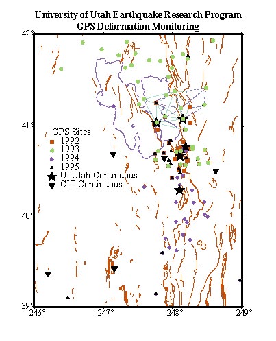
Precise Global Positioning System (GPS) measurements along the 370-km long Wasatch fault in Utah have been made to assess the contemporary deformation of this major Quaternary fault.
Four GPS surveys between 1992 to 1995 occupied 93 stations with average baseline lengths of 44 km and included the reocuppation of 20 sites each year in the Provo, Salt Lake City, and Weber segments of the Wasatch fault. The surveys revealed the unprecedented result that the Wasatch fault zone is experiencing a much greater rate of loading than inferred from the historic earthquake record or the Quaternary fault history .
Uncertainties for the four campaigns averaged 2-3 mm for the N-S and E-W velocity components, and 8-9 mm for the vertical component. The GPS data were also combined with older USGS-NGS trilateration and triangulation observations spanning a longer time window from 1962 to 1994.
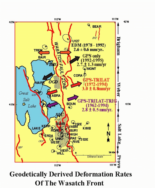
Results from 1992 to 1995 GPS surveys at 30 sites revealed east-west extensional strain at 0.049 ± 0.023 mstrain/yr. These rates correspond to 2.7 ± 1.3 mm/yr. across a 55-km wide region. If the strain is accumulating on the Wasatch fault, assuming a 60° dip, then a contemporary slip rate of ~5 mm/yr is implied.
The GPS-trilateration data from a longer time window, 1972 to 1994, indicate NE-SW extension at 0.054 ± 0.014 mstrain/yr., and the combined GPS-triangulation-trilateration data, 1962 to 1994, demonstrate a similar NE-SW extension direction at 0.051 ± 0.009 mstrain/yr.
The results from the GPS, triangulation, and trilateration indicate an extension rate up to four times greater than previously determined Late Quaternary rates on the Wasatch fault, and up to two orders of magnitude greater than slip rates determined from cumulative moments of historic earthquakes. The relativly high strain rates suggest predominantly aseismic deformation encompassing the Wasatch fault zone.
The GPS data were used as constraints for a simple dislocation model assuming an elastic half-space model and a single fault plane for the Wasatch fault. The GPS data cannot resolve yet whether the slip is concentrated on a single plane or combination of faults or whether it represents uniform extension across this section of the Intermountain Seismic Belt. The data do suggest at least 3 mm/yr of slip must occur below 10-km depth to produce the observed surface deformation. This information is essential to estimate contemporary loading of the Wasatch fault and to serve as a contraint for intraplate dynamic models of the Basin-Range deformation as well as providing new information for probabilistic earthquake risk assessments. Wasatch Front strain rates are listed here
These GPS-determined rates are also high compared to average northern Basin and Range extension rates of ~1 cm/yr across its 800 km width. The GPS rates are comparable with VLBI measured rates across a smaller region of the eastern Basin-Range to Colorado Plateau, encompassing the Wasatch Front.
This information is essential to estimate contemporary loading of the Wasatch fault and plausible hidden faults beneath the populated Wasatch Front valleys. The data also provide important information on the role of vertically and horizontally partitioned slip on active faults and a rheologically stratified crust as well as on temporal clustering of normal faulting earthquakes. This implies a much greater earthquake threat and larger expected ground accelerations.
Wasatch Front Earthquake Risk
The new GPS studies of the Wasatch fault have suggested a much greater earthquake hazard for the Wasatch Front if the deformation is loading the fault. Because of the high population density adjacent to the Wasatch fault, this area is major focus of our research, which includes studies of prehistoric earthquakes, GPS monitoring, earthquake hazard assessment examining fault interaction, and correlation of earthquakes with faulting and probabilistic risk.
Our earthquake hazard research on the Wasatch Front has involved studies of fault interaction and possible flood inundation (by the Great Salt Lake). The initial research results were given in a 1996 AGU presentation by W. L. Chang and R. B. Smith as follows.
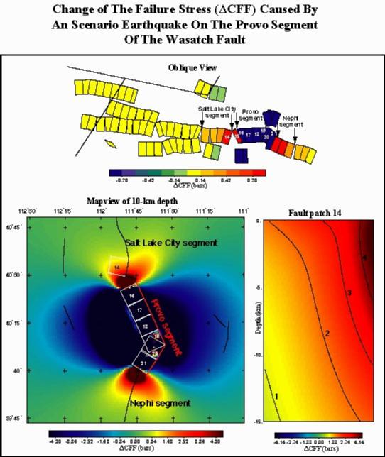
We studied stress changes on the Wasatch fault by examining the space-time behavior of paleoearthquakes on active faults of the Wasatch Front and surrounding area, i.e., M > 7.0 Holocene scarp-forming earthquakes. We employed a 3-D elastic, boundary element code (Simpson, 1994) to examine how the Coulomb stress was perturbed by rupture on nearby fault segments and showed how prehistoric earthquakes may relate to the current state of stress on the Wasatch fault.
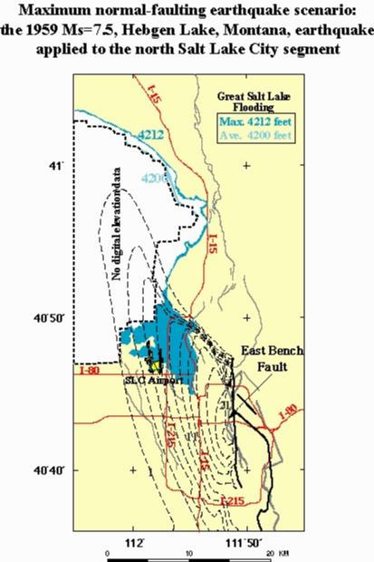
We evaluated an unusual earthquake hazard for the Wasatch Front due to possible flooding by the Great Salt Lake accompanying large normal faulting earthquakes on the Wasatch fault. We first developed a high-resolution topographic data set, then applied the boundary element modeling method to calculate vertical displacements for scenario normal faulting earthquakes. Differences between the undeformed and deformed topography reveals where water could flow into the hanging-wall subsidence basin. We also used the observed ground deformation of the maximum credible earthquake for the Intermountain region, the Ms 7.5, 1959 Hebgen Lake, Montana, as a scenario earthquake. Because of the close proximity of the Great Salt Lake to Salt Lake City, we note that this unappreciated hazard is very important depending upon the lake level and the location and size of the scenario earthquake.