
|
|
|
|
|
|
|
Yellowstone Plume, Hotspot, Teton Fault, and Wasatch Front Earthquake Research
|
Teton Fault Research Highlights
Persistent Seismicity and Energetics of the 2010 Earthquake Sequence of the Gros Ventre-Teton Area, Wyoming
by Jamie Farrell, Robert B. Smith, Frederick Massin, and Bonnie White
Presented at the 2010 AGU Fall Meeting
Seismicity has persisted along a zone south of the Yellowstone volcanic field in the Gros Ventre
Range, Wyoming, and on the eastern edge of the asesimic Quat. high slip-rate Teton fault. Concentrated
seismicity has in this area occurs in sporadic sequences documented since 1923 with notable earthquakes
in the decade preceding the deadly 1925 Gros Ventre slide that eventually lead to the failure of a dam
blocked by the slide in 1927. Notable seismicity of the Gros Ventre region, using data from the Teton,
Yellowstone and USArray seismic networks, has continued in the last decade with sequences in 2002, 2004,
culminating in an energetic sequence beginning in May, 2009 through a sequence of more than 180 well
located earthquakes mainly from August 5 to August 17 of 0.5
Earthquake Hazards of the Teton-Yellowstone Area
Seismicity and earthquake hazard analysis of the Teton-Yellowstone region, Wyoming
by Bonnie Pickering White, Robert B. Smith, Stephan Husen, Jamie Farrell, and Ivan Wong
Published in Journal of Volcanology and Geothermal Research in November 2009
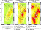
Probablistic seismic hazards were estimated for the Yellowstone and Teton regions using new,
more accurately located earthquake catalogues, geologic fault slip rates, and background
earthquake occurrence rates. The new earthquake catalogues were determined from three-
dimensional seismic velocity models, resulting in more precise hypocenters. The results
of the analysis reveal that the greatest hazards are associated with the Teton fault, which
has a high slip rate of 1.3 mm/yr yet is seismically quiescent with diffuse earthquake
distribution only in the southern Jackson Hole Valley and Gros Ventre Range. In Yellowstone,
hazards are associated with the active earthquake zone between the Hebgen Lake fault zone
and northern caldera boundary, as well as the Mt. Sheridan fault in southeast Yellowstone,
which slip rates of 1.4 mm/yr. The Yellowstone-Teton region is among the regions of highest
seismic hazard in the western U.S.
More Information:
|
|
|
Tectonics of the Teton Fault
The Teton fault, Wyoming: Topographic signature, neotectonics, and mechanisms of
deformation
by John O. D. Byrd, Robert B. Smith, and John W. Geissman
Published in Journal of Geophysical Research in October 1994
Various geological and geophysical methods were used to characterize the evolution
and seismic history of the Teton fault. Mapping reveals the westward tilt of the
hanging wall towards the Teton fault, resulting in anomalous drainage of the
Snake River, which is perched on the westward slope where the river channel was
incised prior to Teton fault displacement. Modeling suggests that the tilt was
caused by 110-125 m of displacement on the fault in the last 25,000-75,000 years
by 10-50 M>7 earthquakes. Seismic refraction and gravity models indicate a total
throw of 2.5-3.5 km, with displacement of Laramide structures whose thrust faults
displaced Precambrian strata which were later uplifted by Teton faulting and
exposed in the high peaks of the Teton Range.
Seismotectonics and Earthquake Hazards of the Teton Fault
The Teton fault, Wyoming: seismotectonics, Quaternary history, and earthquake
hazards
by Robert B. Smith, John O. D. Byrd, and David D. Susong
Published in Geology of Wyoming: Wyoming Geological Survey Memoir No. 5 in 1993
Seismic Exploration of Jackson Lake Structure and History
Seismic surveys and Quaternary history of Jackson Lake, Wyoming
by Robert B. Smith, Kenneth L. Pierce, and Richard J. Wold
Published in Geology of Wyoming: Wyoming Geological Survey Memoir No. 5 in 1993
Teton Fault Field Trip Guide
Neotectonics and structural evolution of the Teton Fault
by Robert B. Smith, John O. D. Byrd, and David D. Susong
Published in Geologic field tours of western Wyoming and parts of adjacent
Idaho, Montana, and Utah: Geological Survey of Wyoming Public Information
Circular No. 29 in 1990
Earthquake Distribution of the Tetons
Seismicity of the Teton-Southern Yellowstone Region, Wyoming
by Diane I. Doser and Robert B. Smith
Published in Bulletin of the Seismological Society of America in 1983
Earthquakes and Landslides around Jackson Hole
Seismicity and the possibility of earthquake related landslides in the Teton-Gros
Ventre-Jackson Hole Area, Wyoming
by Robert B. Smith, J. R. Pelton, and J. D. Love
Published in Contributions to Geology in 1976
The distribution of earthquakes in the Teton region was determined from short-term seismic
deployments and historical accounts, revealing that the Teton fault itself was aseismic,
while diffuse seismicity occurred to the south and west of the Teton fault. Sporadic
earthquakes were recorded from 1870 to 1933, after which the frequency of events diminished.
An area of active seismicity was found in the Mt. Leidy Highlands and Gros Ventre Range,
a region characterized by unstable slopes and several prehistoric landslides. Several
small earthquakes were found to precede the 1925 Lower Gros Ventre slide, with the largest
at M3 or 4 about 20 hours before the slide. It is proposed that regional seismicity can
contribute to landslide hazards by initiating creep through liquefaction in the unstable
slopes and subsequent massive failure.
Field Guide to Geology of Eastern Idaho and the Tetons
Neogene-Quaternary Tectonics and Volcanism of Southern Jackson Hole, Wyoming and
Southeastern Idaho
by David R. Lageson, David C. Adams, Lisa Morgan, Kenneth L. Pierce, and Robert B. Smith
Published in Guidebook to the Geology of Eastern Idaho in 1999
This field trip guide describes an itinerary that visits several sites that illustrate the
complex geologic history of eastern Idaho. Recent, Neogene through Quaternary history is
dominated by Yellowstone hotspot volcanism and Basin and Range-style normal faulting, and
the resulting structures can be seen in the Snake River Plain and nearby mountain ranges.
Additional highlights of the trip (1) include 8 Ma lava flows in southern Jackson Hole that
differ in composition from Yellowstone-related basalts and rhyolites and are of uncertain
origin, (2) slide blocks of paleozoic rocks in Grand Valley that are proposed to have been
emplaced during major ignimbrite eruptions from the Heise volcanic field, (3) the Teton
Range and Jackson Hole and the evolution of the Teton fault, and (4) the proposed southeast
Idaho lineament, a possible tear fault that may accommodate shifts in deformation and
seismicity.
Return Seismology and Active Tectonics Home Page
